Mogollon Culture
Large-scale cultures are determined through comparisons of multiple elements: architecture, food, food processing, weaponry, burial practices, storage vessels, symbology, ritual artifacts, etc. Archaeologists trace the evolution of tribes similarly as the people collect and carry on together for a period of time, then they disappear into the landscape and shortly, another group comes together and carries on again under, perhaps, a different tribal umbrella.
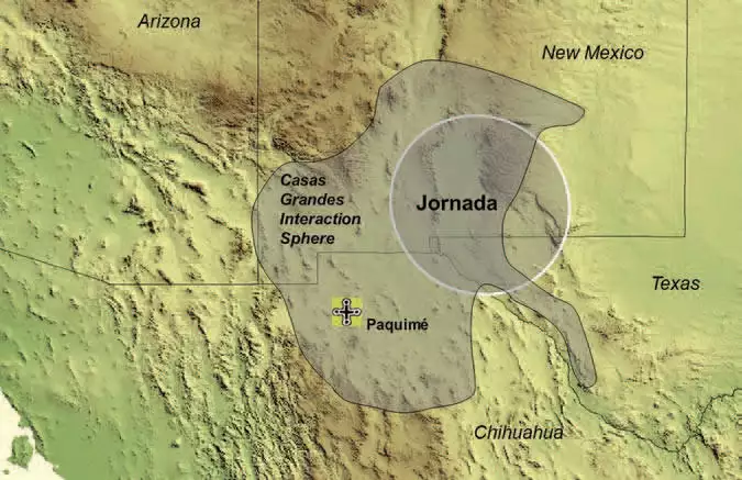
It's in the comparison of artifacts against already-established archaeological timelines and locations that have led to defining the Mogollon Culture as distinctly existing from around 300 CE to about 1450 CE, in an area stretching from the central western coast of Mexico northeast through Chihuahua, then north to the Gila and San Andres Mountains, then northwest along the Mogollon Rim to the Little Colorado River area in northeastern Arizona. The name, "Mogollon", has been attributed to a Spanish governor in the early days of colonization, it has nothing to do with the people themselves.

Corrugated pot sherds recovered from Casa Malpais
Because of their location, virtually all trade between the Southwest and central Mexico crossed Mogollon territory. The further from central Mexico that trade got, the more it was funneled through certain areas simply because of the availability of local water: in the desert the people walked from water hole to water hole. They had no large beasts of burden to carry things for them. They never invented the wheel. But there was significant trade between the Southwest's turquoise mines and central and southern Mexico. From about 1100 to about 1450 CE, most of that trade was funneled through Paquimé and the Casas Grandes area. Then came the extended global bad weather periods in the mid 1400s and the Mogollon Culture essentially faded out: their settlements seem to all have been abandoned in the same decade, everywhere. This happened with the Hohokam, the Fremont and several small groups of Ancestral Puebloans at the same time. The Zunis survived as a distinct presence but they also drew their boundaries and their people back into closer positions along the Zuni River.
The people of Paquimé most likely moved south and west over the mountains to slightly more hospitable countryside. There they developed new customs, new architecture and new symbology to go with new religion and ritual. Those global bad weather events convinced them that their religion (and its gods) were flawed. The bad weather destroyed crops, destroyed trade routes, destroyed societal hierarchies and essentially wiped out the cultural wealth they had gathered over the centuries: they had to start almost from square one again, except this time they kept most of their scientific and engineering technology, simply adapting it to changed circumstances.
The Mimbres Mogollon people had already abandoned their main landscape after the bad weather events of the mid 1100s, but they seem to have spread out into the countryside, what some call the "Jornada," surrounding their original constructions in the Mimbres Valley. Mimbres artifacts have been found in the canyons on the both the east and west sides of the San Andres Mountains and in the mountains north of the Gila and Black Mountains. We don't know for certain that they settled the area around Acoma because Acoma is a living village and no excavation has ever been allowed there. But Acoma potters have been picking up potsherds with Mimbres designs on them for many years. Same for potters at Isleta and Laguna.
Other Jornada Mogollon villages have popped up all along the Rim, up to about the area of Springerville, AZ. There are several Mogollon village ruins around Springerville that were abandoned in the mid 1400s. Close to them were several other villages of Ancestral Puebloans who also abandoned the area around 1450 CE, most of them going north to the Hopi mesas.
The indigenous people of the Rio Salado area were trading with the Mogollon before the Hohokam arrived in the 600s. The Hohokam in the valley pretty much kept to themselves but they encouraged trade between the local folks and the Hohokam Core cities downstream. After the Hohokam had left the valley around 1050, the local folks went back to trading with the Mogollon people to the northeast. Then in the early 1200s a group of Kayenta potters came south from the Four Corners area, crossed Mogollon territory and took up residence in the Salt River Valley. As a group, they traded in pottery and obsidian. They sent out trading missions from the Tonto Basin until they, too, a couple hundred years later, disappeared into the landscape in the mid 1400s.

Above-ground stone walls of a square kiva, typical of a Mogollon kiva, Casa Malpais, AZ

Stone walls of multiple kivas partially in the ground, also typical of Mogollon style, Casa Malpais, AZ

The OasisAmerica region in the Southwest
Photo of Casa Malpais corrugated pot sherds is courtesy of Claire S. Barker
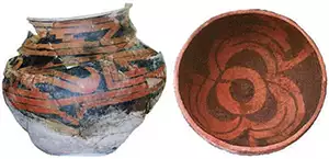
El Paso Polychrome pottery photo is courtesy of the Environmental Division, Fort Bliss Military Reservation

