Main Subjects
Pueblos
Non-Pueblos
Artists
Shapes & Forms
Design Elements
Southwestern Prehistory
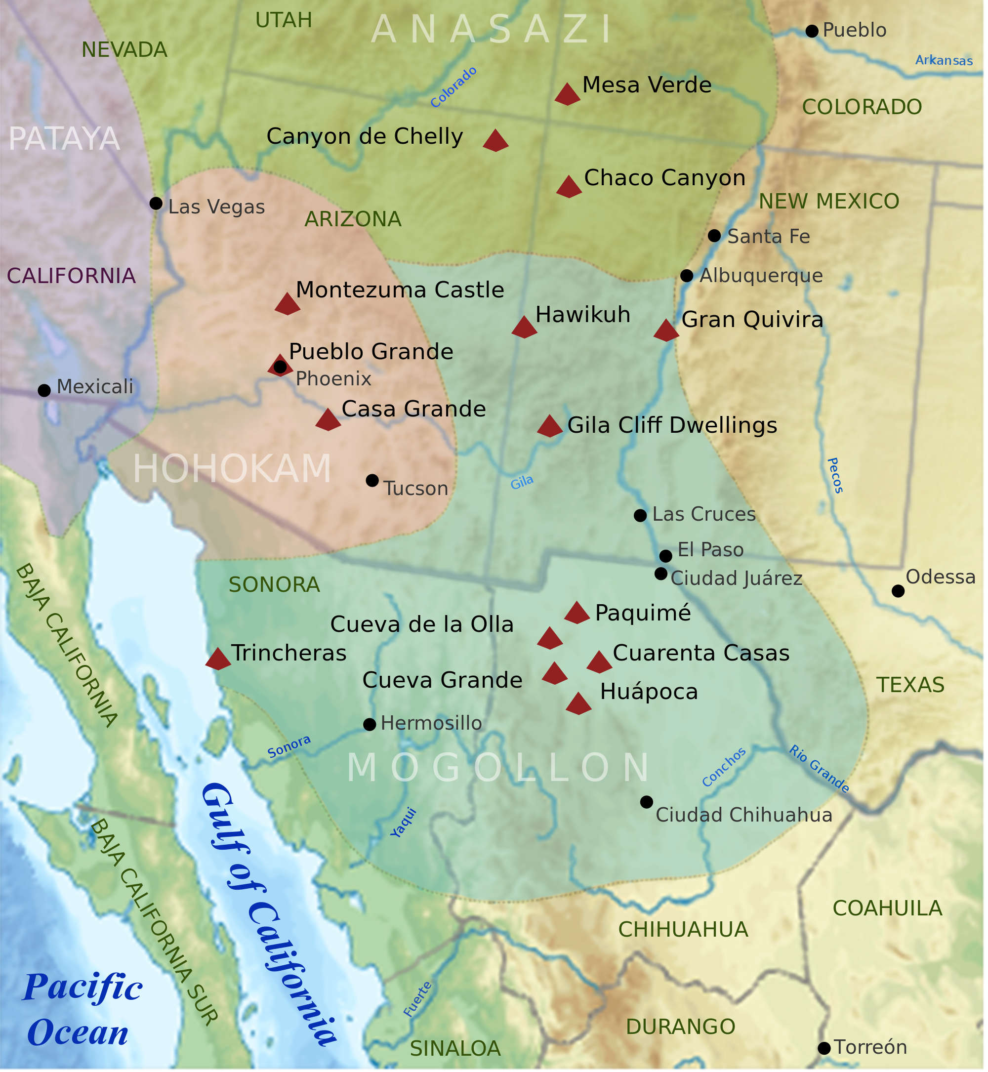
Areas of influence in the southwestern states
click on the map for a larger version
The southwestern states saw Native American people moving across the landscape for thousands of years. "Folsom Point" arrowheads of the Clovis culture have been dated to be as much as 13,000 years old and have been found from the Mississippi River valley on the east to the Sierra Nevadas on the west, from northern Mexico to Montana. That's physical evidence there was a lot of travel and trade happening across a lot of countryside over thousands of years.
The Clovis culture is named for a discovery site at Blackwater Draw, near Clovis, New Mexico. Archaeologists have found numerous arrowheads there of the distinctive Clovis type dated up to 13,000 years ago. Another burial site found in central Montana had the remains of an infant surrounded by various items including Clovis arrowheads. The body was interred about 12,600 years ago. Artifacts from the Clovis culture indicate it was possibly the first widespread culture in the New World. Some archaeologists say the Clovis culture lasted from about 13,000 years ago to about 12,600 years ago. Some say it was around longer, we just haven't found the evidence yet.
About 12,000 years ago a comet-strike occurred, precipitating the Younger Dryas event. A comet (or large asteroid) entered the Earth's atmosphere and broke up. Pieces came down across the northeastern part of North America, across the North Atlantic and into the British Isles and Scandinavia. It brought an almost-overnight climate change event that precipitated the refreezing and advancement of Ice Age glaciers that lasted for a thousand years. That comet strike, the climate change and the ensuing glacial advance spelled the end of the nearly-ubiquitous Clovis culture. It was during the thaw after the Younger Dryas eased that the Athabaskans in Alaska and northwestern Canada began their migrations east of the Rocky Mountain Cordillera and then south onto the Great Plains.
Pueblo societies didn't begin to evolve until the people began to develop agriculture and that couldn't happen until a whole series of other advancements happened. Someone had to connect seeds, water, dirt, sunlight and time to the plant growth that matured into food. They had to sort out the times for planting and harvesting and what to do for maintenance. Then, if they were successful, they had to develop methods of processing it for consumption. Then they had to develop means of storage to keep the rodents, reptiles, insects and birds out.
One of the early elements allowing the people to settle was the arrival of maize seeds that grew and matured into cobs of plump kernels of corn. That importation appears to have come from the south, happening in several waves of advancing technology over the last several thousand years. Archaeologists have found the remains of maize kernels that exhibit different characteristics: the earlier ones being the first to offer a substantial seed and the later ones being more productive with an even larger kernel. But there is a whole context around the seed, the seed isn't the whole answer by itself. An entire agricultural technology had to be evolved and then adapted to individual situations. A cotton seed that was developed about 3,000 years ago in South America was being cultivated by the people in southern Arizona about 2,000 years ago. That same seed is still being grown on several pueblos, its cotton still being spun into thread and woven into belts and garments.
One thousand years ago there were four major cultural groups in the southwestern states: the Mogollon, the Ancestral Puebloans, the Hohokam and the Patayan. The Patayan mostly occupied southwestern Arizona (along the Colorado River) and southern California and Nevada. The Hohokam were dominant in south and central Arizona. The Mogollon were in southwestern New Mexico, southeastern Arizona and northern Mexico, spread out along the geological structure known as the "Mogollon Rim" and reaching down to the west coast of Mexico along the Sea of Cortez. The Ancestral Puebloans occupied northern Arizona, northwestern New Mexico, southwestern Colorado, southern Utah and southeastern Nevada. There were many cultural similarities between the Mogollon and the Ancestral Puebloans, fewer similarities between either of them and the Hohokam and even fewer with the Patayan.
Irrigation was first developed in the Southwest by the Hohokam and the technology emanated from there along the various trade routes. Pottery was possibly first brought north by traders and migrants from central Mexico. In the Southwest it seems to have been first developed among the Hohokam, the Mogollon and the Chacoan people around the same time. All three cultures were already shipping turquoise south in exchange for other trade goods. At first the locally made pottery was small and rough but it shortly developed shape and design esthetics. The pottery also changed form as uses for it progressed. Designs on it progressed as their technology and spirituality developed. There came a time when large vessels of pottery were used to construct evaporative coolers that served the ancients as refrigerators. There also came a time when larger bowls and serving dishes were made for religious feasting purposes, to help bond disparate families and peoples together in times of upheaval and mass migrations. Feasting was also used to cement religious hierarchies in place among the people.
In prehistoric times there was major north/south trade involving the transporting of pieces of turquoise south and returning north with seeds, technology, copper bells, seashells, macaws and new religions. For instance, turquoise from the Villa Grove area of the northern San Luis Valley in Colorado has been traced as far south as the Mayan temples of Chichen Itza on the Yucatan Peninsula and Copán in Guatemala. Because of their perceived value in Mesoamerica, tens of thousands of pieces of turquoise mined all across the Southwest made their way to many destinations in the south over hundreds of years, same as many thousands of copper bells and seashells made their way north. There's no way to judge the volume of the trade in macaws but when Paquimé was excavated, they found the remains of more than 50 macaws in specially built pens.
Trade virtually stopped in the mid-1400s CE, about the same time Paquimé and the Hohokam cities were abandoned. It has been speculated that the trade routes across the desert got too dangerous after that. There is also global evidence of several volcanic eruptions whose ash clouds caused multiple years of decreased temperatures and increased rain and snow around the world in the 1450s and 60s. Major, almost-overnight and long-lasting changes in the weather could well be seen as "messages from the gods" that something isn't right here, and maybe we should move somewhere else. A religion focused on the Sun might not have done so well in years when the Sun couldn't be seen for months on end, hidden as it was behind thick clouds of volcanic ash. To have that then fade into sunny decades of drought...
Possibly the last major infusion of indigenous religion came north out of Paquimé in the early 1200s and made its way to the Four Corners area relatively quickly. It has been termed "The Flower World Complex" and concerns teachings about the bird-, butterfly- and flower-filled paradise that awaits us after we die... The Complex has its origins in Mexico's Central Pacific area, although even there it may have been a descendant of something taught previously in Teotihuacan. Within a few years of its arrival, society in the Four Corners area turned upside down and there was an out-migration that quickly depopulated the entire area. In 1257 CE Mount Samalas, a volcano in Indonesia, erupted, belching out a volume of ash that darkened skies around the globe for several years. However these events were interpreted by the people and their priests in the Ancestral Puebloan world, the symbology and design patterns of the Flower World are still being recreated on Pueblo pottery today.
I have often wondered about the timing and the cause of these events. The migrations really began in earnest in the 1100s as whole villages moved around. That was blamed on a Great Drought and most evidence has agreed with that. Evidence has also pointed to another Great Drought beginning around 1275 and continuing for about 20 years. Then came the events of the 1450s and 60s: forever-grey skies, long winters, cold summers, increased rain and snow leading to poor crops, famine and people starving to death. That gave way to an even greater drought in the late 1400s. But the people had been living in this countryside for thousands of years and their oral histories had seen it all. They were survivors, but something seemed to be different about the 1100s, the mid-1200s and the mid-1400s.
Then I came across the story of the Mount Samalas volcano eruption in Indonesia, happening sometime between May and November, 1257 CE. The 1200s was a time of more active volcanoes around the world and they were having a cumulative effect on global climate, but Mount Samalas was the big one: that explosion left a caldera almost 5 miles across. The atmospheric ash from Samalas brought summer snows to Europe, Asia and the Southwest for several years, beginning in 1258. It brought increased moisture to many places around the world for several years, too, then they were all plunged into drought and famine conditions. The Mount Samalas eruption has been credited with ending the several-centuries-long Medieval Climate Anomaly and beginning the Little Ice Age that caused depressed temperatures around the world for the next several centuries.
After other major volcanic eruptions in 1108, 1171, and 1230 had affected the global climate, to the Ancestral Puebloans the forever-grey skies and summer snows of 1258-1262 that led to long winters, flash floods and famine may have been seen as a final failure of their religion. Then a long term drought set in again around 1275. Somewhere in that time period the rock art changed and got more complex with a more spiritual component added. It seems that is also the time period of the first emergence of katsinas and the Warrior and Sacred Clown societies. Moieties didn't happen everywhere and where they did happen, they seem to have evolved later.
The atmospheric events of the 1450s and 60s coincided with the disappearance of a distinct Mogollon culture all across the Southwest. The Paquimé and Casas Grandes areas were abandoned. Same for every singularly identified Mogollon pueblo the length and breadth of their countryside. The Salado, Sinagua and Hohokam cultures disappeared about the same time, too. The Ancestral Puebloans, the Zuni and the Hopi seem to have come through those years pretty much intact, but each group was diverging from the paths of their earlier ancestors in different ways. That's how we got the different languages we have today. The 1400s is when archaeologists have dated the entrance of the Apache and the Diné to the neighborhood, too.
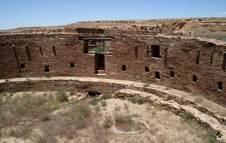
Casa Rinconada in Chaco Culture National Historical Park
Many of the ancient pueblo structures that have been excavated indicate they were built in times of adequate or above average rainfall. Some of them were occupied for hundreds of years, some for thirty years or less. Two elements they all had in common: round underground religious structures and square and rectangular above-ground masonry structures (the Mogollon also built above-ground living quarters but they also built square and rectangular above-ground kivas). The underground religious structures most likely emerged because of the area-wide commonly held belief that "the people" emerged on this Earth through a hole in the ground, a sipapu. The Archaic Basketmakers lived in small huts above ground or in pithouses partially dug into the ground. There is evidence that some pithouses evolved into kivas as residential complexes were built above ground.
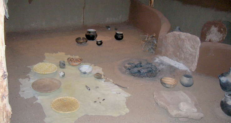
Ancestral Puebloan pithouse display at the BLM's Anasazi Heritage Center
Puebloan pottery is an art that has been honed over hundreds of years. However, pottery is an indication of a relatively stable lifestyle as the nomadic lifestyle with its constant motion requires the use of less weighty and less fragile storage vessels, like woven baskets. Pottery couldn't develop until the people settled down a bit and that couldn't happen in the arid Southwest until the principles of irrigation were disseminated through the area: agriculture in the desert requires knowledge of irrigation principles, a stable water source and enough people available to do the work of developing (and then using and maintaining) an irrigation system. All of this first requires a reason for its development: a seed that is easy to grow and matures into a large fruit bearing many kernels. Maize was perfect for that. Harvested maize also needed protection from the elements, especially from water and from hungry rodents, insects, birds and reptiles.
The oldest bits of pottery archaeologists have uncovered in the Southwest were associated with pithouses. The general construction of pithouses indicates a society that is still semi-nomadic but increasingly sedentery because of their development of agriculture. Over time, areas that grew more crops attracted more people. More people meant a larger aggregation of technological knowledge and more workers for putting that knowledge to work. Often that work involved digging and operating irrigation systems. A more centralized work area required a more centralized population, which required larger and more stable living structures... and the cycle repeated itself until any particular settlement (or group of settlements) got into trouble when the climate varied negatively for any period of time. Looking back from the present, many structures were built almost as disposable units. Many structures were occupied for only thirty or forty years while others were occupied for one-to-two hundred years. It's only been over the last thousand years that communities have come into existence that are still inhabited after several hundred years: Taos, Acoma and Old Oraibi in particular. Most of the other pueblos have been moved and rebuilt since the time of the Spanish arrival.
For the most part, daily-use pottery was functional in design and usually an unpainted gray in color. From about 500 to about 1300 CE, decorated pottery began to develop, usually using painted designs on a white or gray background, designs that turned black in the firing process. Polychrome designs began around 1150 with the use of various mineral-based pigments. By the 1200s, bright colors grew more popular and in the 1300s, highly developed motifs and designs were developed from the Rio Salado area in Arizona to the newly settled Rio Grande Pueblos in New Mexico.
The designs and style changes have been traced to significant social changes among the people. The geographical movement of the styles has been mapped to the movement of people as their climate changed. The Salado people once were classed as a subset of the Hohokam culture, people who lived all across central and southern Arizona. Then further excavation showed that "Salado" was more a culture of pottery makers with perhaps different spiritual intent, visible in the decorations on their pottery. There is also evidence that the makers of Salado pottery did not merge well with pre-existing communities in the Rio Salado area. The culture of the pottery itself migrated across the Southwest and was made anew in each new locale of materials local to that locale. The pottery itself wasn't something that was traded long distance from a single source. Likewise, the Sinagua have been classed as a subset of the Ancestral Puebloans whose present-day descendants are among the Pueblo peoples of northern New Mexico and northeastern Arizona. However, the Sinagua also showed great knowledge of Hohokam irrigation systems and built them everywhere they went. Some of their constructions are still in use today.
One more thing: among the people, the making of pottery is sacred work. Every aspect of the process, from first gathering the clay all the way through to removing it from the fire, is accompanied by appropriate prayers. Some potters see it as infusing spiritual energy in the finished piece. But it goes further than that. The tribes have many clans and each clan has its own area of action within the lives of the people. Each clan has its own ritual specialists: people who know the costumes, the dances, the songs, the music, the prayers, the textiles, the pottery and the designs.
Even today, a tribe may decide they are short of one specialist or another and they will make a deal with another tribe that has that clan knowledge available. Sometimes they send someone to learn the rites and then bring them back. Other times they invite specialists to come and live with them and teach them the rites. I've come across a potter at Acoma who was born and raised at Zia, married into Zuni and moved to Acoma when her family was invited to strengthen an Acoma clan. Many times the clans have their own special designs, their own methods of decorating textiles and pottery. Those designs have a power and meaning of their own, especially when applied by someone who speaks the language of the prayers fluently.
A Hopi Creation Story, a story with echoes throughout the worlds of the pueblos.
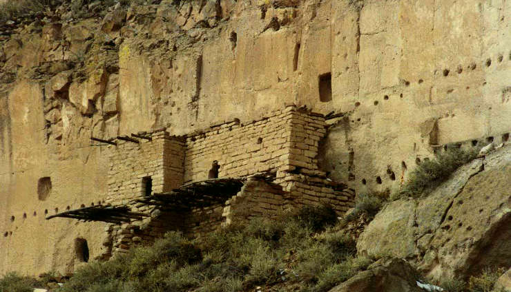
Puye Cliff Dwelling at Santa Clara Pueblo
One breakdown of the Ancestral Puebloan period looks like this:
- Archaic/Early Basketmaker Era - (7000 to 1500 BCE) This is the big gap, after the Clovis people disappeared and before any larger local societies came together. During this time period, though, civilizations were beginning to flourish way down south. Large irrigation systems were in use to grow food to feed relatively large city populations in northern Peru around 3,000 BCE. People were making pottery around the same time, too, in Peru and Ecuador. They built monumental works, including platforms, pyramids and multi-storied buildings. It was thought the avocado was first served as food in central Mexico around 8,000 BCE but evidence has surfaced dating the introduction of avocado to around 15,000 BCE in Peru. Maize has a similar back-and-forth thing between northern Peru and central Mexico. One thing is clear: certain artistic design elements have been in use by indigenous people in the Americas for more than 5,000 years. Those elements seem to have coalesced into part of the Flower World Complex, a postulated spiritual philosophy that can be traced from ancient Peru to today's Southwest. At the same time, in the Southwest a lot of rock art appeared. A "Plateau-Plains rock art tradition" has been postulated, extending from the Mojave Desert east to the staked plains and from southern Utah to the Chihuahuan Desert. Consisting mostly of straight lines, block figures and spirals, it comprises virtually all rock art made before about 1260 CE. Then the rock art across the Southwest changed in the space of one generation.
- Early Basketmaker II Era (1500 BCE to 50 CE)The beginnings of the roughest pithouses. The Hohokam are building their first irrigation works but most people in the southwest are simple hunter-gatherer nomads, migrating back and forth across the countryside with the seasons and the wildlife. Rough ceramics first appear.
- Late Basketmaker II Era (50 to 500 CE)Pithouse technology spread across the southwest as new strains of maize appeared, most likely carried north from central Mexico by immigrants from that area. The new maize had larger kernels and offered a much better food source, if only decent soil and regular water were available and if the folks took the time to protect it a bit while it grew.
- Basketmaker III Era (500 to 750 CE) The first decorated pottery began to emerge as tribes and families settled down more and grew more maize. The first above-ground houses appeared and many pithouses were converted into the first kivas. The people began to gather together in villages and those villages began to coallesce into societies.
- Pueblo I (750 to 900 CE) Pueblo buildings were constructed of stone with south-facing windows, and in U, E and L shapes. The buildings were located closer to each other, reflecting deepening religious celebration. Some kivas had towers built nearby, towers most likely used for look-outs. Pottery became used for more than just cooking, and included pitchers, ladles, bowls, jars and dishware for food and drink. White pottery with black designs first emerged in this time period, the pigments being developed from the boiling down of plants. Water conservation techniques and complex irrigation systems using reservoirs and silt-retaining dams also emerged during this period.
- Pueblo II (900-1150 CE) During the Pueblo II period the population increased so much that more than 10,000 sites were created in 150 years. Since most of the countryside was arid, the people supplemented their diet by foraging, hunting and trading pottery for food. By the end of the Pueblo II period, there were many two-story dwellings made almost exclusively of stone masonry. Towers were beginning to appear and family and community kivas began to develop. This was the time of the Mimbres Mogollon culture.
- Pueblo III (1150-1350 CE) There was a significant community change during the Pueblo III period. This was the time of Chaco Canyon, Mesa Verde and Pottery Mound. Much of the population moved in from dispersed farmsteads to community centers at canyon heads or to cliff dwellings on canyon shelves. Population peaked between 1200 to 1250 at more than 20,000 in the Mesa Verde region alone, far more than could be sustained for any length of time. Then came a massive volcanic eruption on the other side of the planet that blotted out the sun. That caused a couple years of cooler weather, heavier precipitation and no summer, then led into a 25-year drought. By 1300 the Ancient Puebloan people abandoned most of their settlements as a result of climate changes, food shortages and dwindling resources. Many of them migrated to villages in northern Arizona and northwestern New Mexico with more stable water sources. Many in New Mexico spent 50 or more years living in the Chama River Valley or on the Pajarito Plateau before migrating closer to the Rio Grande river bottom.
- Pueblo IV (1350-1600) The Pueblo IV time period saw many tribes and familes still migrating toward more stable water sources, and building "disposable" (not meant to be occupied for more than a few years) pueblos along the way. The Towa expanded eastward to Cicuyé. Some Eastern Keres moved into the Galisteo River drainage and some Tewa moved south into the Santa Fe River basin, merging into Tanoan pueblos where they could and building new pueblos where there were none before. Potters there developed a multi-colored lead glaze from the turquoise, silver and lead formations found in the Cerrillos Hills. Due to trade connections with tribes from the eastern Plains, Cicuyé became one of the largest and most prosperous settlements in the Puebloan world, rivaled only by Picuris Pueblo to the north.
The Santa Clara people first built the dwellings at Puyé on the eastern slopes of the Jemez around 1200 CE. It was completely abandoned around 1600 CE when the Santa Clarans moved further down the hill to where the Santa Clara River meets the Rio Grande. Most of the other Tewa people had already come down out of the Jemez and, after making a centuries-long stop in the area around what is now Bandelier National Monument, moved on to settle where they are now.
- Pueblo V (1600-present) Pueblo V saw the arrival of the Spanish and a consolidation of Puebloan tribes and lands. The arrival of the Spanish turned their world upside down, beginning in earnest in 1598. Conditions under the Spanish were so bad the pueblos banded together and revolted in 1680, and successfully threw the Spanish out. The Spanish came back in force in 1692 and began again a little differently. But there was pushback from the people and their villages were sometimes looted and burnt, only to be rebuilt a few years later a bit differently.
The above timeline is focused primarily on the more studied aspects of prehistory: the Ancestral Puebloan ruins and the tracks of the people's migrations. Something to keep in mind are the events of the latter half of the 1200s. Climate change had been taking a toll for a couple hundred years already but something was the final straw and resulted in the complete depopulation of the Four Corners area. When those people migrated, they moved into areas that were already long populated by perhaps slightly less cultured, less technologically advanced people.
From the 1100s into the 1200s, there was a buffer zone, a no-man's-land if you will, between Chaco Canyon and the Gallina highlands to the northeast. The Gallina people resisted the Chaco folks mightily, and killed anyone crossing the line, no matter what their purpose. When Chaco became depopulated in the mid 1100s, the Gallina people's enmity extended to the northwest, toward the Mesa Verde area. Gallina ruins suggest the people perhaps didn't want to be as technologically advanced and they practiced a variation of Chaco religion, one where men weren't always dominant. By the time the Eastern Keres people came flooding through the Jemez Mountains and down the valley of the Rio Jemez, the Gallina people were an impediment no more. They seem to have drifted down out of the highlands and melted away into the villages below.
Which brings up the villages below. The entire Northern Rio Grande area had long been populated by Tanoan people. Their technology, too, was perhaps a bit behind the Ancestral Puebloan times. The out-migration from Mesa Verde happened more in family units than in whole villages. It was a gentler relocation of people than just an unmitigated flash flood of hungry bodies. As migrations had been happening in earnest since the 1100s, societies had developed ways of meeting, welcoming and merging newcomers into their local societies. Those were the days of large feasts and religious celebrations: get everybody dancing, singing and eating together and we'll all be okay. This worked in some places but not in others. In some places the pushback was intense.
In some cases, it was also several hundred years before the folks leaving Mesa Verde arrived at their destinations along the Rio Grande. Many journeyed along the upper San Juan River, across the Jemez Mountains and down the Rio Jemez. Others skirted the northern slopes of the Jemez and moved out onto the Pajarito Plateau before dropping into the Rio Grande valley. Still others crossed southern Colorado and dropped south into the Ojo Caliente area before reaching the Rio Chama and following it to the Rio Grande. At every step of the way they were met by evidence of Tanoan people having been there for centuries already. Eventually, they merged into the Tanoan villages and gave rise to the differentiations of Tewa, Tiwa and Eastern Keres. Towa is spoken today only by the people of Jemez. There is some speculation it is a descendant of the language the Gallina people spoke. However, the Pueblo of Jemez states that their people began the migration from Mesa Verde around 1275 and arrived in the Cañon de Don Diego in the early 1300s. They have been there ever since.
The Spanish also brought about a massive depopulation simply through the spread of diseases they were immune to, but the indigenous people weren't. With the Spanish came Franciscan priests intent on forcing the indigenous people to build great mission structures to glorify their Christian God, while destroying any indigenous religion and working and taxing the people to the brink of death. The 19 Rio Grande Pueblos survived the transition to Pueblo V, as did Ysleta del Sur in Texas and the pueblos on the Hopi mesas in Arizona. Around 1625 is when Sikyátki (at the foot of First Mesa) was destroyed and during the winter of 1700-1701, Awat'ovi (on Antelope Mesa) was destroyed. The Spanish destroyed Picuris in 1692 and Picuris still hasn't fully recovered. Several of the Rio Grande pueblos were burned by the Spanish between 1692 and 1696 but when the people came back down out of the hills, they usually rebuilt close by. The Piro pueblos were mostly destroyed during the Pueblo Revolt of 1680 and they were never resettled. The Tompiro pueblos were completely depopulated by the mid-1700s, wiped out by European diseases and never reoccupied.
The last residents of Cicuye Pueblo were invited to join their kin in the Jemez Mountains and they moved there in 1838. The Santa Fe Trail came by a few years later and many Anglo-European migrants along that trail marveled at the large empty edifice with its oversized mission structures.
The Galisteo Basin pueblos had been decimated by disease and abandoned years before. They were the pueblos most specialized in the production of glazed ceramics but their access to the lead they needed for their glazes was denied by the Spanish after 1694. With that, they lost their most valuable products for trade and things quickly went downhill for them. Within a few years the survivors had migrated down Galisteo Creek and merged into Santo Domingo. Pueblos in the Santa Fe River Basin saw their people try to relocate more to the north near Santa Clara. Then there was a problem with the Spanish and a priest was killed. They were forced out of the Rio Grande area and shortly relocated to the area of Hopi First Mesa. They did better there, and are now known as "Hopi-Tewa."
Upper photo courtesy of the National Park Service
Pithouse photo courtesy of eyesofthepot.com, CCA-by-SA 4.0 License
Lower photo courtesy of Einar Kvaran, CCA-by-SA 3.0 License
Pithouse photo courtesy of eyesofthepot.com, CCA-by-SA 4.0 License
Lower photo courtesy of Einar Kvaran, CCA-by-SA 3.0 License