Main Subjects
Pueblos
Non-Pueblos
Artists
Shapes & Forms
Design Elements
The Sinagua Culture
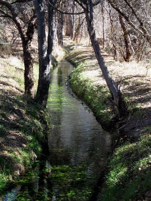
A Sinagua irrigation ditch
at Montezuma Well
The Sinagua (meaning: without water) people occupied the area of north-central Arizona from the Salt River north to the Little Colorado River and around the north side of the San Franciso Peaks Volcanic Field. That includes most of the Verde River Valley and parts of the Mogollon Rim in Arizona. Archaeologists have dated the Sinagua culture as extending from about 500 CE to about 1425 CE when the last of their major structures was abandoned.
Several modern Hopi clans trace their ancestry back to Sinagua migrants leaving the Verde Valley for religious reasons. There are also stories among the Hopi and Zuni of the fireworks that accompanied the eruption of Sunset Crater Volcano around 1060 CE. Those stories could only have been passed into their oral histories by migrants moving away from and then returning to the San Francisco Peaks area at the northern end of Sinagua territory. Some Hopi still return to ancient Sinagua sites to perform religious ceremonies in honor of their ancestors.
Archaeologically speaking, the area east of the Grand Canyon and northeast of the San Francisco Peaks was occupied perhaps as early as 500 CE. The area wasn't very populated and most of the people lived in pithouses. Water was scarce and farming and hunting were marginal. When the volcano erupted, they ran for their lives. Most seem to have run south to the Sycamore Canyon and Verde Valley area. Some may have gone northeast to Kayenta and Tusayan.
A few decades later, the lava was cool. Almost everything east of the volcano was blanketed with a thick layer of ash and cinders. That ash and cinders held rainwater really well, and long-lasting moisture held promise.
The people returned and thrived. The crops were good, the population grew, the old pueblos were rebuilt and larger structures were built, too. Then in 1257 CE, Mount Sambalas in Indonesia blew up and plunged the world into darkness and volcanic winter, flooding and drought. Within a few years of that, even the religion had changed. The people left the most arid lands and generally headed upstream along the riverbeds in search of more conducive habitat.
Within a few years, people from the Kayenta area (east and north of Wupatki and Wukoki) were roaming the countryside in search of similar peaceful habitat. Some of the migrants came together in the area of Homol'ovi, on the banks of the Little Colorado River, for a few decades. There was an old pueblo still-occupied at Homol'ovi but it blossomed into four distinct pueblos very quickly. Then, as the weather grew bad again in the 1400s, Homolovi was abandoned. Most of the people headed upstream again. Some went northeast to the Hopi mesas, some went southeast to what is now the Fourmile Ranch/Springerville, AZ area.
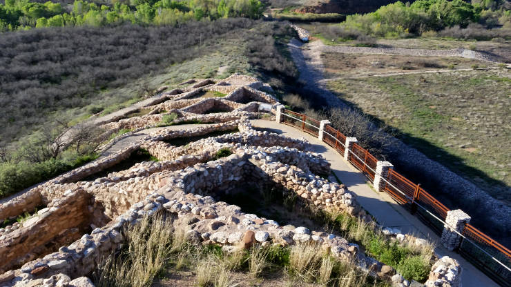
Looking south from the top of Tuzigoot

Cultures of the Southwest
1350 CE
The Fourmile Ranch area is a few miles from the older Jornada Mogollon settlements near Springerville. The newcomers set themselves up in the Fourmile Ranch area and traded with the Jornada Mogollon. There was also a cross-pollination of arts (especially pottery) and culture (clans and rituals). Then came another giant volcanic eruption across the world on the China-Korea border. That volcano spewed massive amounts of ash into the atmosphere for several years, bringing on volvanic winter conditions around the Northern Hemisphere. That led to Puebloan abandonment of the area in the mid 1400s. When the first waves of Athabascans arrived, they were entering a countryside devoid of people.
It is speculated that some of the potters made the journey to the Hopi mesas as some of the designs in use at Fourmile Ranch/Springerville made the journey to Hopi and were seen hundreds of years later on the surfaces of pottery made by Nampeyo of Hano. The reasoning is: How else did those designs make that journey? It's a similar conundrum to "Sikyátki" designs being developed at Pottery Mound before migrating to Awatovi and Sikyátki. Those same designs were also made famous hundreds of years later by Nampeyo. It is speculated that Nampeyo found those designs on pot sherds littering the ground around abandoned villages only a few miles from her home at Hano on First Mesa.
It is also speculated that some of the people migrated east, eventually to Zuni, Acoma and Laguna. Just upstream from Springerville, along the Little Colorado, is an abandoned pueblo the Zunis feel is their true homeland. That particular region is also along the eastern edge of Salado territory and there is evidence in the area of cross-pollination with that source. The Salado were on the move at the same time, migrating out of their valleys also in search of peace and better weather.

Southern and Middle Sinagua pueblos
included in the Verde Confederacy
It wasn't long before the people headed upstream again, up the Zuni River to where the Zunis are now. At the time of Coronado's arrival, the Zunis were living in several (7 or 8) major and minor pueblos. When the Spanish returned 60 years later, only two survived.
In some respects, the Sinagua were a "buffer" people between the Ancestral Puebloans to the north and east (with their masonry pueblos and dryland farming) and the Hohokam to the south (with their advanced irrigation systems and extensive trade routes). Early Sinagua constructions were pithouses, built to sustain daily life while the folks engaged in subsistence agriculture. As they developed irrigation systems, the population grew and they built larger and larger pueblo structures. Trade developed and artifacts from the West Coast and from Mesoamerica have been found in the remains of some villages.
In the 1300s, like the Salado, all Sinagua constructions became defensive. That's an indicator of a rise in hostilities in the neighborhood. Shortly, families and clans were migrating in search of a better place for themselves.
The Sinagua culture has been broken into two distinct subsets: the northern Sinagua, based around the Flagstaff and San Francisco Peaks area, and the southern Sinagua, based around the Verde and Agua Fria River valleys.
The northern Sinagua left behind abandoned pueblos at Walnut Canyon, Wupatki and Elden Pueblo. The southern Sinagua left abandoned pueblos at Tuzigoot, Sycamore Canyon and Montezuma Castle. Parts of the irrigation system they built at Montezuma Well have been dug out and are in use today.
Many of the northern Sinagua seem to have migrated into the upper Little Colorado River basin and then to the Hopi mesas. The southern Sinagua seem to have gone mostly east to the Zuni, Acoma and Laguna areas. A few went south to the Hohokam, but the Hohokam were also feeling the effects of a severe drought and their culture was collapsing, migrating outward in all directions. In 1350 CE the Valley of the Sun (the home of Hohokam Pueblo Grande) was the most densely populated area in the southwest. By 1450 it was almost completely depopulated.
By 1500 CE, east and central Arizona were home to nomadic bands of Apaches. Northeastern Arizona, northwestern New Mexico, southwestern Colorado and southeastern Utah had become home to the Diné. The Hopi were still on their mesas but they were surrounded. The Fremont people of Utah had disappeared, as had the Jornada Mogollon of southern New Mexico and eastern Arizona. In northern Mexico, the Jornada Mogollon cities at Paquimé and Casas Grandes and their associated Great Houses and rancheros were abandoned.
By the time the Spanish arrived in the 1500s, most of the countryside was populated by ghosts, often a result of minor changes in the climate but also abandoned because of warfare, and possibly changes in religion. The Spanish brought diseases that almost wiped out the remaining population. 60 years later came more Spanish priests, military and settlers to finish the job... Perhaps the Sinagua people saw that coming and just melted away... There were still a few people living in their countryside but it wasn't nearly like it was before.
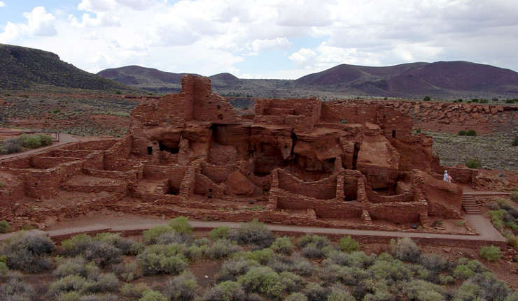
Wupatki, an abandoned northern Sinagua pueblo northeast of the San Francisco Peaks
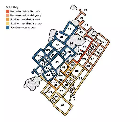
The room layout of Wupatki Pueblo
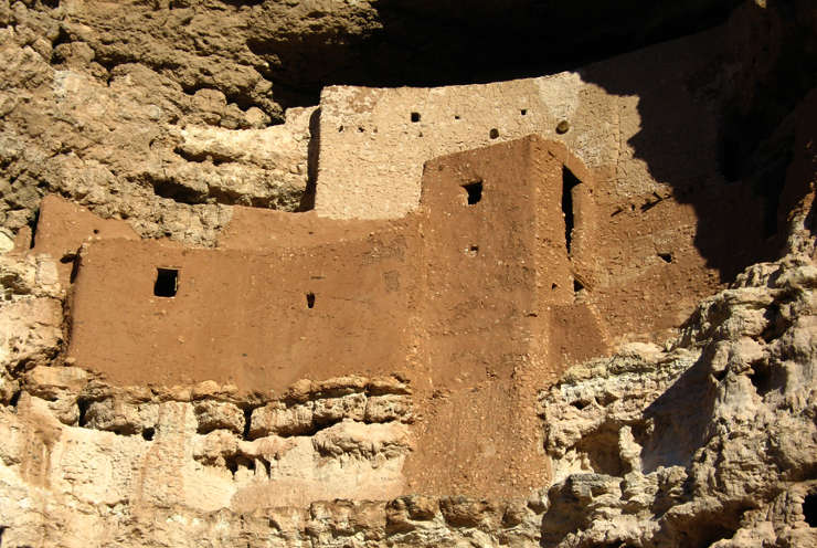
Montezuma Castle
Upper photo courtesy of the US Forest Service
Photos of Tuzigoot and Wupatki courtesy of eyesofthepot.com, CCA-by-4.0 License
Other photos courtesy of the National Park Service
Photos of Tuzigoot and Wupatki courtesy of eyesofthepot.com, CCA-by-4.0 License
Other photos courtesy of the National Park Service