Main Subjects
Pueblos
Non-Pueblos
Artists
Shapes & Forms
Design Elements
Wupatki and Wukoki

The setting of Wupatki

The tower at Wukoki
The landscape is littered with old volcanic cinder and spatter cones. The stratovolcano at Kachina Peaks is a few miles to the southwest. None of these volcanic remnants has erupted in almost 1,000 years but the ruins at Wupatki National Monument were occupied before those last eruptions and then rebuilt a few decades after.
This is the Colorado Plateau and the climate was a bit wetter back in those days. The Sinagua, Cohonina and Kayenta Anasazi inhabited the area, growing crops, hunting wild game and making pottery. Indigenous people had inhabited the area for maybe 10,000 years before Sunset Crater erupted around 1,085 CE. Hopi and Zuni elders tell stories about watching the "fireworks" happening when the volcano was letting blast.
When the eruptions were over, the landscape had changed considerably and was newly fertilized with the addition of fresh-fallen ash and minerals. Better crop yields were able to support a larger population. That larger population was better able to construct better living quarters.
The pueblos at Wupatki and Wukoki were rebuilt and reoccupied, probably reaching their zenith in the late 1100s CE. Reconstruction of the Citadel was begun about the time the others were being completed but the climate was already starting to get drier and the farming started producing less food. By about 1250 CE these pueblos and their surroundings were completely abandoned.

The remains of Wupatki
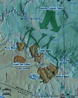
Migrations of the Kayenta-
Tusayan people, 1200s CE
Wupatki was the largest multi-room structure in the area but even at its height, it might have had no more than 100 residents. Wukoki was smaller and the Citadel smaller yet. But there may have been several thousand people living within a day's walk and these three ruins were the big towns of that time: cultural, religious, political and trading centers. One of the ruins found in this area has been tentatively identified as being a "ball court" similar to ball courts found among the Hohokam settlements in southern Arizona and among the Mesoamerican cities of Mexico and Central America. When Wupatki was excavated, they found the remains of 41 scarlet macaws. There were also many copper bells and drilled sea shells, all brought north from societies in western and southern Mexico. It is speculated that trade in turquoise is what made that possible.
The structures were built of flat red sandstone pieces mortared together in what is now called "stack architecture." Logs were brought in from the mountain forests and used for roof/floor beams. Around each central living structure was a series of pithouses and smaller pueblos. The buildings were located close to springs that flowed in those wetter days (but don't flow now - now the only water here is pumped up out of 900-foot deep wells). Also near each pueblo structure is a large catch pond, to catch rain water for irrigation.
When the Great Drought of the late 1200s set in, Wupatki, Wukoki, the Citadel and numerous other local pueblos were abandoned. Most of the people headed south to Homol'ovi and beyond as part of another wave of Kayenta-Tusayan migrants. Some of them may have been the spark that ignited the Salado culture.

The remains of Wukoki

The external wall of the Citadel

Inside the wall in the remains of the Citadel
Photos courtesy of Eyesofthepot, CCA-by-SA 4.0 License
Sites of the Ancients and approximate dates of occupation:
Ancestors Index
Atsinna : 1275-1350
Awat'ovi : 1200-1701
Aztec : 1100-1275
Bandelier : 1200-1500
Betatakin : 1275-1300
Casa Malpais : 1260-1420
Chaco Canyon : 850-1145
Atsinna : 1275-1350
Awat'ovi : 1200-1701
Aztec : 1100-1275
Bandelier : 1200-1500
Betatakin : 1275-1300
Casa Malpais : 1260-1420
Chaco Canyon : 850-1145
Cicuyé : 800-1838
Fourmile Ranch : 1276-1450
Giusewa : 1560-1680
Hawikuh : 1400-1680
Homol'ovi : 1100-1400
Hovenweep : 50-1350
Jeddito : 800-1700
Kawaika'a : 1375-1580
Fourmile Ranch : 1276-1450
Giusewa : 1560-1680
Hawikuh : 1400-1680
Homol'ovi : 1100-1400
Hovenweep : 50-1350
Jeddito : 800-1700
Kawaika'a : 1375-1580
Keet Seel : 1250-1300
Kuaua : 325-1580
Mesa Verde : 600-1275
Montezuma Castle : 1200-1400
Payupki : 1680-1745
Poshuouingeh : 1375-1500
Pottery Mound : 1320-1550
Puyé : 1200-1580
Kuaua : 325-1580
Mesa Verde : 600-1275
Montezuma Castle : 1200-1400
Payupki : 1680-1745
Poshuouingeh : 1375-1500
Pottery Mound : 1320-1550
Puyé : 1200-1580
Sikyátki : 1375-1625
Snaketown : 300 BCE-1050
Tonto Basin : 700-1450
Tuzigoot : 1125-1400
Wupatki/Wukoki : 500-1225
Wupatupqa : 1100-1250
Yucca House : 1100-1275
Snaketown : 300 BCE-1050
Tonto Basin : 700-1450
Tuzigoot : 1125-1400
Wupatki/Wukoki : 500-1225
Wupatupqa : 1100-1250
Yucca House : 1100-1275