Main Subjects
Pueblos
Non-Pueblos
Artists
Shapes & Forms
Design Elements
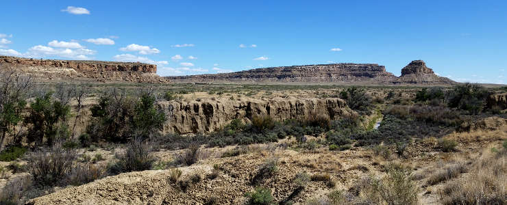
Chaco Canyon
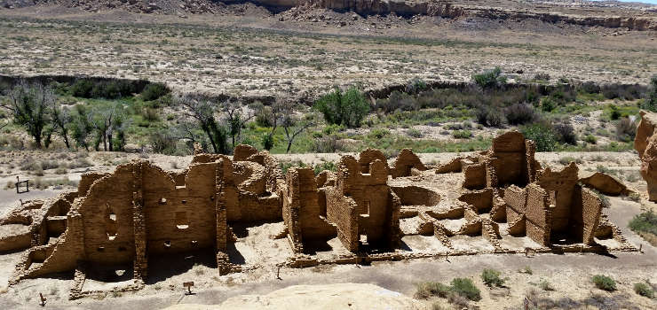
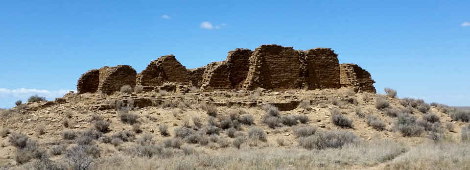
The ruin of Kin Kletso
Chaco Canyon was the center of trade, religious ceremony and governmental administration for the Four Corners area from about 800 CE to about 1150 CE, during what archaeologists now call the Pueblo II & III eras. These are attributed to have been the Ancestral Puebloans. Their expression of civilization was marked by large, pre-planned masonry constructions, advanced geometries, explicit astronomical alignments, fine engineering and developed landscaping that added up to an impressive urban center of spectacular public architecture.
Looking at what remains in Chaco Canyon today, it's hard to believe an urban center the size of this one could have grown and flourished in this high desert landscape with short growing seasons and marginal rainfall. Obviously, the climate had to be significantly wetter for most of the time from at least the mid 700s to the early 1100s CE. Construction of Pueblo Bonito is said to have begun around 800 CE, built to exacting astronomical orientations and architectural standards. Several of the other Great Houses were built in the late 800s and early 900s, built to the same standards. The builders used masonry techniques unique for the time, constructing multi-storied edifices with hundreds of rooms each. Each was built to a pre-specified plan, in contrast to the previously-normal method of cobbling on extra rooms as they were needed. Some of these buildings must have taken decades to complete, some might have taken a century or more. Each structure is definitely recognizable as a representative of mature Chacoan architecture.
The landscape of the whole of Chaco Canyon was taken into account for the whole of the construction here. Communication between the Great Houses, smaller pueblos and kivas was by line of sight. Each construction was placed explicitly among sacred mesas, shrines and mountains, surrounded by communication features, astronomical markers, water control devices and formal earthen mounds used for ceremonial purposes. This was the Ancestral Puebloan version of "Feng Shui" on a colossal scale.
Oral histories of the Acoma, Jemez, Rio Grande Pueblos and the Dineh indicate that Chaco Canyon was the home of the Great Gambler, an entity that came from the south, enslaved the people during their migrations and forced them to build the great constructions in Chaco Canyon before he was outwitted and driven away.
Impressive roads traveled cross-country from Chaco in all directions, connecting with more than 150 other Great Houses and smaller pueblos spread around the Four Corners region. This network of roads is overgrown and eroded to the eyes of Earthbound travelers now but is still visible to anyone looking down from space. Chaco Canyon was the center of a trading network that trafficked in turquoise, macaws, sea shells, copper bells and other commodities, many items coming from thousands of miles away in the Pacific coast area of central Mexico.
Construction in the canyon started to slow in the 1100s and ground to a halt in the early 1200s. Like what was happening in many other places in the Four Corners area, Chaco Canyon was essentially abandoned by 1250 CE. The abandonment has most often been blamed on climate change and exhaustion of resources in the canyon, but we don't know. There could well have been other reasons, too. Some have said that Chaco was ruled by men and offered little place for women. After several hundred years of that exploitation, the women stopped working and started walking away. Many of the people moved north in the mid-1100s to newer pueblos built in the area of Aztec on the Animas River. Many went further and reoccupied older pueblos in the Greater Mesa Verde area and in the Chuska Mountains while others moved east into the Jemez Mountains or south to locations along the Rio Puerco. After Chaco's male dominated religion had failed them, these were more female-dominant societies.
In 1257 CE a volcano in Indonesia blew its top in what has been called "the most powerful volcanic explosion in the last 2,000 years." It had effect all over the globe with tens of thousands of people dying of famine in Europe and Asia. England saw a projected 30% death toll in 1258 alone, attested to by the discovery of mass graves in the London area holding thousands of men, women and children. There was no summer for a couple years, only freakish weather and cold, hard rains. This global cascade of events was discovered only a few years ago and has never been calculated into the why's of Mesa Verde abandonment. But a couple years of iron-gray skies, massive downpours and flash floods with no agricultural production must have had an effect on a society that worshipped the sun and the rain, especially when that weather pattern was soon followed by torrential rains, floods and then decades of drought.
That might have caused a further collapse of faith in the ancient, male-dominated religion. Folks likely shifted away from the long-established Chacoan ways and their religion and spirituality evolved. However, warfare increased and became almost genocidal in the latter 1200s. Where small raids for food and women had become common over the years, this was a step up to scorched Earth policies: whole villages were destroyed with all residents killed and their pueblos burned.
Then, the Katsinam appeared. The Katsinam were a collection of about 250 deities that are said to have power over the elements of the world. They appear after the Winter Solstice and before the spring rains. They leave again after the Summer Solstice. Bringing the rains and the sun back are among their primary purpose. The Katsinam brought a greater male dominance back to their societies. By the time the Great Drought was in full swing, most people had already left the Four Corners/Mesa Verde area. As the people flowed across the countryside from there to where they are now, world views changed as new societies and sodalities formed. Over the centuries that followed, that male dominance took hold in Hopi and Zuni but not so much in the Rio Grande Pueblos. It took Spanish/Christian intervention to force a form of male-dominance on them, but those are stories for other places.
Many tribes and clans in the Southwest trace their ancestries back to Chaco. Some return regularly to carry out ceremonies to honor their ancestors in what is still a very sacred place.
The earliest known map of the area was drawn in 1776 by a Spanish cartographer named Bernardo de Miera y Pacheco. Chaco Canyon had already been abandoned for more than 500 years by then. I would imagine those early Spanish explorers were surprised to stumble on something as large and magnificent as Chaco must have looked back then.
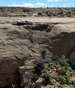
An ancient canyon stairway
Today, most folks begin their visit to Chaco Culture National Historical Park at the Visitor Center (museum, theater, information desk, gift shop, bookstore, restrooms). From the Visitor Center, there's a 9-mile paved loop road that accesses the parking areas for six major sites in the valley: Hungo Pavi, Una Vida, Pueblo del Arroyo, Pueblo Bonito, Casa Rinconada and Chetro Ketl. There are well-marked self-guided trails from each parking area to and through each set of ruins. There are several trails that lead along the canyon walls and offer close-up views of petroglyphs and other rock art. There are also four marked backcountry trails that access some of the more remote sites and features, including stairways, petroglyphs, ancient roads and spectacular valley overlooks. The trails are open from sunrise to sunset but you'll need a free backcountry permit before going hiking there. Camping is not allowed in the back country: camping is allowed only at Gallo Campground.
To get there: The primary route to Chaco Culture National Historical Park is via US Highway 550. Turn south off US 550 about 3 miles southeast of the Nageezi Trading Post (at mile post 112.5) on County Road 7900. From that turnoff, there's eight miles of pavement (CR 7900) and 13 miles of packed dirt and gravel road (CR 7950) to the Chaco Culture National Historical Park Visitor Center. A word of warning: Many of these modern GPS mapping/guide services may direct you to take other roads in the area. The road I took the first time I went to Chaco is one of those and is no longer usable. Many of those other roads are on reservation land and see no maintenance. They will eat typical passenger cars as snacks before breakfast. CR 7950 is maintained regularly and is the most direct route to where you want to go.
There are also roads that reach Chaco Canyon from the south: Warning! The best roads are rough to impassable, the others are beyond ridiculous, unless you happen to be driving a rock crawler and it's been dry out for a few weeks...
Fajada Butte in the distance, near the entrance to the park
Pueblo Alto
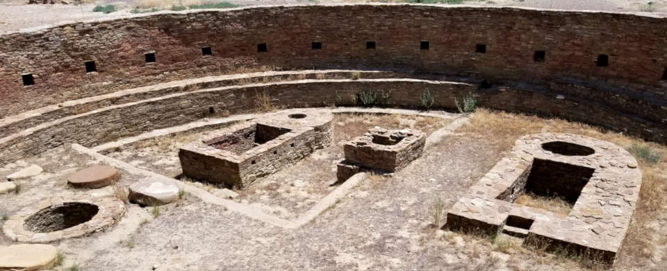
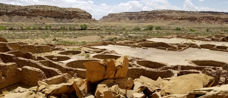
A group of ceremonial pits inside the main kiva at Chetro Ketl
Chetro Ketl
| Pueblo Bonito | 800-1150 CE |
| Una Vida | 850-1090 CE |
| Peñasco Blanco | 900-1125 CE |
| Hungo Pavi | 1000-1080 CE |
| Chetro Ketl | 1005-1110 CE |
| Pueblo Alto | 1030-1145 CE |
| Casa Rinconada | 1070-1105 CE |
| Pueblo del Arroyo | 1070-1105 CE |
| Casa Chiquita | 1100-1130 CE |
| New Alto | 1100-1130 CE |
| Kin Kletso | 1100-1130 CE |
| Wijiji | 1105-1120 CE |
| Tsin Kletzin | 1105-1120 CE |
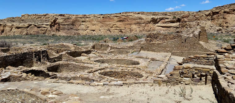
Chetro Ketl began as a modest building, a single-story room block, probably around 1010 CE. About 100 years later the building had been expanded until the structure covered almost three acres with an estimated 500 rooms: about 225 rooms on the first floor and about 275 rooms on the second and third floors. The overall ground plan of Chetro Ketl is a D shape with the arc of the D formed by the front wall of the plaza. One of the kivas off the central plaza shows evidence of having been intentionally burned. The central plaza itself has been artificially raised about 12 feet above the surrounding landscape, perhaps in an effort to mitigate periodic flooding from heavy runoff on the cliffs behind the site.
Some of the room blocks in Chetro Ketl preserve the ancient wall plaster and floor/roofing elements. Some rooms have painted wall murals in them, usually geometric designs in shades of red, blue and green. Floors and ceilings were built of primary beams crossed perpendicularly with willow rods followed by sequential layers of juniper bark and mud plaster. It has been estimated that to build Chetro Ketl it would have taken about 26,000 trees harvested in forests dozens of miles away. The walls are generally built in a core-and-veneer manner with roughly shaped stones set flat in a mud mortar core and carefully selected shaped stones used to make the veneer around the core. The decreasing widths of walls as they rise from the first floor to the third indicate the upper floors were planned before the first floor was built.
In excavating one of the kivas in the Chetro Ketl complex, archaeologists found four sandstone discs layered beneath the floor, separated from one another by layers of adobe. Beneath the fourth disc they found two alternating layers of adobe and lignite (low grade coal). In the center of the circle they found a suede leather bag containing powdered turquoise.
Fronting on the plaza's southern perimeter is a row of one-story rooms connecting the east and west room blocks. Each room was finished on all four walls and there were well-plastered floors laid between them. At one time, the rooms were roofed but over time they filled with soil and rubble flowing down from the plaza area above. Chetro Ketl grew to become one of the largest Great Houses in Chaco Canyon, second only to Pueblo Bonito.
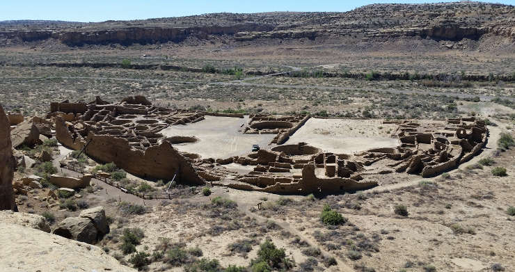
Pueblo Bonito
Pueblo Bonito
Pueblo Bonito was the earliest, largest and longest-in-use of the Chaco Canyon Great Houses. The name comes from Lieutenant James Simpson when he was engaged in a military mission into Navajo territory in 1849. He and his Mexican guide, Carravahal, named the abandoned structure using the Spanish for "Beautiful Town." There are also Hopi, Pueblo and Navajo names for the structure.
Construction at Pueblo Bonito began around 800 CE and continued for about 300 years, ceasing in the early 1100s. Pottery sherds found in the complex indicate the site was lightly inhabited into the 1200s but not for long. Researchers today estimate the year-round population of Pueblo Bonito to have been between 50 and 100 people with major influxes for seasonal and ceremonial purposes. Those same researchers estimate the entire year-round population of Chaco Canyon at its height to have been between 2,000 and 6,000 people, based on the number of rooms with fire pits, the quantity of pottery sherds found and the amount of arable land in the canyon.
Excavations during the 1920s revealed the existence of a great many room foundations linking Pueblo Bonito with Chetro Ketl through the now-open, sparsely-vegetated landscape between the two. Subsurface imaging later revealed the underground existence of many more rooms, foundations and kivas in that space.
Archaeologists studying the designs on pot sherds noted that early Chaco potters and early Mogollon potters may have used cross-hatching to denote colors (all they had to work with was grey-white clay and black paint). Then they found the same design motif (with cross-hatching) on both a Chaco bowl and a Mimbres Mogollon bowl. The Chaco plate also had an inlaid piece of blue turquoise while the Mimbres plate had an inlaid piece of green turquoise. The argument followed that the blue turquoise represented the male-dominant Chaco religious system while the green turquoise represented the female-dominant Mimbres religious culture. Both cultures had long traded with societies in northern and central Mexico, sending turquoise south and bringing macaws, copper bells, seashells and other goods north. A new religious complex may have accompanied the traders moving up and down that trail in the mid-700s and turned the ancient Southwest on its head. That vision was part of something now termed "The Flower World Complex," an ideology formed around the promise of a wondrous world of flowers, birds, fish, butterflies and frogs that we go to after we die, should we live our lives within that rule set (sound familiar?).
Within a few generations, an elite class formed and the priests of this new religion essentially became the rulers. A power and wealth inequality set in. In order for many of the Great Houses in Chaco Canyon to be constructed the way they are, in the places where they are, some master group had to be in charge and directing the constructions. Some of those constructions took generations of workers to complete.
A similar power-and-wealth inequality flowed into the clans, too. The family of the clan mother had advantages in life others in their clans didn't have. Clan leadership passed mother-to-daughter. If there was no daughter, it passed mother-to-niece. As relationships got further away from the central family, advantages dropped off. Many people lived on the fringes and had nothing more than dry, barren, agriculturally-challenged land to work with. There were other clans, too, and advantages dropped off the later their clan was deemed to have arrived on-site. And advantages varied with how large and powerful that clan was. But the religious rulers were all men, and they had other advantages.
Deeper analysis has determined that the people who inhabited Pueblo Bonito year round may have been significantly taller and larger than the average Native American of the time. Some of them may also have had red hair. Some of them may have been polydactyl, too. They had a diet that consisted of more animal protein than the common people. They had access to the best agricultural fields and collected offerings with their rituals. Some say they collected tribute from villages on the far edges of their influence. They were healthier and lived longer lives (the average lifespan of a commoner back then has been determined to be around 27 years, while the elites averaged a 51-year lifespan).
In Pueblo Bonito archaeologists have also found evidence of human sacrifice and cannibalism, indicating the Great House was likely the religious center of Chacoan society. Those practices fell off after the people moved north to Aztec and the Mesa Verde area but they weren't completely ended until just before Mesa Verde was depopulated. Some have speculated that the depopulation of Mesa Verde coincided with the end of the elites that had ruled their society for hundreds of years. Everyone who walked away was essentially a commoner. Over the next few generations, new clan societies formed and religious rituals and imagery evolved.
Some of the kivas at Pueblo Bonito
Pueblo Bonito from the back side
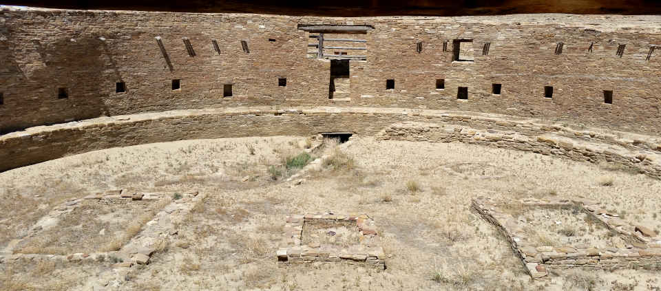
The Grand Kiva at Casa Rinconada
The park is open from sunrise to sunset every day. The visitor center is open from 8 am to 5 pm daily except Thanksgiving, Christmas Day and New Years Day. Camping at Gallo Campground is best rated as "slightly developed" (meaning: tent pads, picnic tables and fire pits or charcoal grills). There are no hookups of any kind at any of the 49 regular and 2 group sites. There is also no shade (although I do remember there being one tree that cast a bit of shade over one campsite early in the morning). The stay limit is seven days and vehicles over 35' don't fit. Bring your own firewood or charcoal, there's none available at the park and gathering firewood is not allowed. Same as there's no food, gasoline or ice available at the park. There is drinking water available at the Visitor Center. You'll find telephones there, too. There are flush toilets in the campground but no showers. Site #16 and both restrooms are universally accessible.
Chaco Culture National Historical Park was declared a UNESCO World Heritage Site on December 8, 1987, joining a select list of protected areas around the globe "whose outstanding natural and cultural resources form the common inheritance of all mankind..."
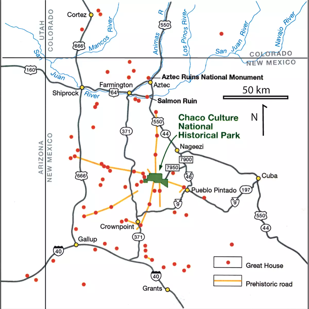
Map showing locations of other Great Houses and roads around Chaco Canyon in the 1100s
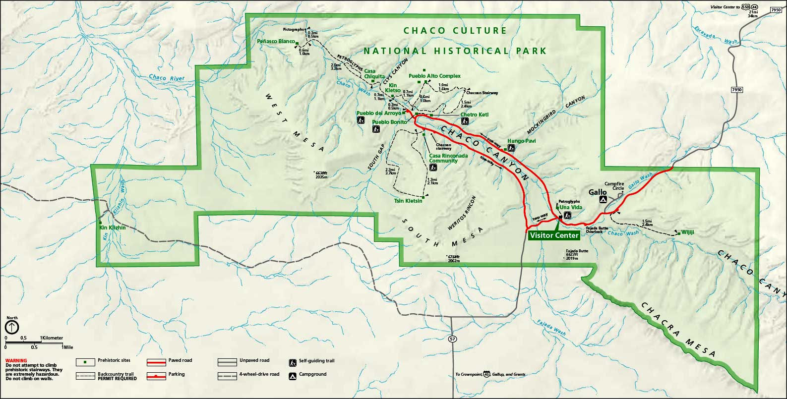
Chaco Culture National Historical Park map: Click on the map to see a larger version
Maps are courtesy of the National Park Service
Photos courtesy of EyesofthePot, CCA-by-SA 4.0 License
Photos courtesy of EyesofthePot, CCA-by-SA 4.0 License
Sites of the Ancients and approximate dates of occupation:
Ancestors Index
Atsinna : 1275-1350
Awat'ovi : 1200-1701
Aztec : 1100-1275
Bandelier : 1200-1500
Betatakin : 1275-1300
Casa Malpais : 1260-1420
Chaco Canyon : 850-1145
Atsinna : 1275-1350
Awat'ovi : 1200-1701
Aztec : 1100-1275
Bandelier : 1200-1500
Betatakin : 1275-1300
Casa Malpais : 1260-1420
Chaco Canyon : 850-1145
Cicuyé : 800-1838
Fourmile Ranch : 1276-1450
Giusewa : 1560-1680
Hawikuh : 1400-1680
Homol'ovi : 1100-1400
Hovenweep : 50-1350
Jeddito : 800-1700
Kawaika'a : 1375-1580
Fourmile Ranch : 1276-1450
Giusewa : 1560-1680
Hawikuh : 1400-1680
Homol'ovi : 1100-1400
Hovenweep : 50-1350
Jeddito : 800-1700
Kawaika'a : 1375-1580
Keet Seel : 1250-1300
Kuaua : 325-1580
Mesa Verde : 600-1275
Montezuma Castle : 1200-1400
Payupki : 1680-1745
Poshuouingeh : 1375-1500
Pottery Mound : 1320-1550
Puyé : 1200-1580
Kuaua : 325-1580
Mesa Verde : 600-1275
Montezuma Castle : 1200-1400
Payupki : 1680-1745
Poshuouingeh : 1375-1500
Pottery Mound : 1320-1550
Puyé : 1200-1580
Sikyátki : 1375-1625
Snaketown : 300 BCE-1050
Tonto Basin : 700-1450
Tuzigoot : 1125-1400
Wupatki/Wukoki : 500-1225
Wupatupqa : 1100-1250
Yucca House : 1100-1275
Snaketown : 300 BCE-1050
Tonto Basin : 700-1450
Tuzigoot : 1125-1400
Wupatki/Wukoki : 500-1225
Wupatupqa : 1100-1250
Yucca House : 1100-1275