Bandelier

The foundations of Tyuonyi

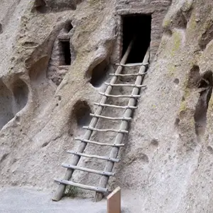
A kiva ladder to an upper apartment
Beginning in the mid and late 1200s, the areas that are now included in Bandelier National Monument became an increasingly popular refuge for Ancestral Puebloans and other northern San Juan people fleeing the drought devastating their homelands in the Four Corners region.
A perenially wet canyon located in the high, forested lands of the Pajarito Plateau, Frijoles Canyon was an oasis to them. Between about 1250 CE and 1500 CE they built dwellings up the faces of the volcanic rock cliffs and, in other areas, built stone and volcanic ash pueblos in the open along the stream beds.
For many years the land was good to them, then we don't know if the weather got drier again or if the people outgrew the ability of the land to sustain them all. Either way, they had to move.
By the time the Spaniards arrived in the mid 1500s, the Pajarito Plateau had been abandoned. The former residents had moved downstream to build pueblos closer to the Rio Grande. This is where we find most of their descendants today. The people of Cochiti, Santo Domingo, San Felipe and even some Zunis trace some part of their lineage back to Frijoles Canyon.
The people of San Ildefonso trace their lineage to the Tsankawi area (Tsankawi is an undeveloped, non-contiguous piece of Bandelier National Monument located about 11 miles to the north of Frijoles Canyon).
The people of Santa Clara trace their migration from the area of Yucca House in Colorado to the Puye Cliffs (northeast of Tsankawi on the Santa Clara Reservation) to where the village of Santa Clara is today. The people of San Juan/Ohkay Owingeh trace their lineage back through the canyons along the Chama River and up the valley to Ojo Caliente. They got to Ojo Caliente by traveling east from the Four Corners area along the San Juan River to the Pagosa Springs area, then south over the mountains. For all these pueblos, the slopes and canyons of the Jemez Mountains is sacred land. Because there are pueblo ruins going back many years all through the Jemez Mountains and its drainages, the government of Jemez Pueblo was in Federal court for years trying to lay claim to the entire mountainous area.

Frijoles Canyon

A reconstructed kiva on the floor of the canyon
The Tsankawi area is bounded by San Ildefonso Pueblo to the east and south and by Los Alamos National Lab to the north and west. Tsankawi is essentially undeveloped and has never been excavated. There is a parking area along the side of NM Route 4 at the trailhead. The trail is a loop about 1.5 miles long and used to lead past many cliff dwellings, a large unexcavated village and a lot of petroglyphs. That said, the trail has been rerouted over the years and on my last hike of it, there was virtually nothing of any note left to see.

The remains of ancient dwellings carved into the cliff wall

More living space carved into the cliff wall

Rock art preserved on the cliff wall
Sites of the Ancients and approximate dates of occupation:
Atsinna : 1275-1350
Awat'ovi : 1200-1701
Aztec : 1100-1275
Bandelier : 1200-1500
Betatakin : 1275-1300
Casa Malpais : 1260-1420
Chaco Canyon : 850-1145
Fourmile Ranch : 1276-1450
Giusewa : 1560-1680
Hawikuh : 1400-1680
Homol'ovi : 1100-1400
Hovenweep : 50-1350
Jeddito : 800-1700
Kawaika'a : 1375-1580
Kuaua : 325-1580
Mesa Verde : 600-1275
Montezuma Castle : 1200-1400
Payupki : 1680-1745
Poshuouingeh : 1375-1500
Pottery Mound : 1320-1550
Puyé : 1200-1580
Snaketown : 300 BCE-1050
Tonto Basin : 700-1450
Tuzigoot : 1125-1400
Wupatki/Wukoki : 500-1225
Wupatupqa : 1100-1250
Yucca House : 1100-1275