Main Subjects
Pueblos
Non-Pueblos
Artists
Shapes & Forms
Design Elements
Betatakin

Betatakin

Looking at the ruins from
beneath the overhang
Betatakin is a Navajo word meaning "House built on a ledge." The Hopi name is Talastima, meaning "Place of the Corn Tassel."
Located in an arm of Tsegi Canyon, Betatakin is part of the Kayenta-Tusayan historic area. The pueblo was abandoned well before the Navajo came into this countryside.
Betatakin consisted of about 120 rooms and one kiva. Because of rock fall over the years, only about 80 rooms can still be accessed.
Dendochronologists have determined that logs to build the pueblo were stockpiled on-site between 1269 and 1272. Then there was a burst of constriuuction between 1275 and 1277. At that point, an entire village moved in in an orderly fashion and lived there for a couple decades, Then they began leaving the area until it was finally compleltely abandoned before 1300. At its height Betatakin consisted of about 120 rooms and one kiva. The maximum population was maybe 120 people.
The lifetime of Betatakin was about the same time period as the Great Drought, from 1276 to 1298. This was a long term drought that affected people all over the Four Corners area. It was one of the principal reasons leading to the final abandonment of Mesa Verde, Yucca House, Aztec and Hovenweep.
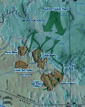
Migration routes followed by the
Kayenta people in the late 1200s CE
Tsegi Canyon may have been better for the people early on in the drought because each of the pueblos built in plenty of grain storage space as they were being built. However, as the drought wore on, more and more people entered the area looking for food and things got rough. Eventually, it got to be too much and many of the remaining people migrated to either the Hopi mesas or down the Colorado River to Havasupai.
Others went south to the Homol'ovi and Fourmile areas, too, but that didn't last long as those folks were also moving out in the face of bad weather. There has also been a Kayenta migration tracked going further to the south, essentially becoming the Salado culture in the Tonto Basin and, through their pottery and their obsidian trade, they have been traced from there going as far south as Paquimé and into the Pacific coast area in central Mexico. Like many other small cultures of the time, some returned to their ancient homelands while the rest faded into the local background and essentially disappeared during the climate events of the mid-1400s. We know where they went by following the trail of perforated plates they left behind (perforated plates are uniquely a Kayenta innovation for the making of pottery).

Tsegi Canyon

Looking down on Betatakin from the canyon rim
Pictographs on a canyon wall near Betatakin
Photos courtesy of the National Park Service
Map courtesy of Archaeology Southwest
Map courtesy of Archaeology Southwest
Sites of the Ancients and approximate dates of occupation:
Ancestors Index
Atsinna : 1275-1350
Awat'ovi : 1200-1701
Aztec : 1100-1275
Bandelier : 1200-1500
Betatakin : 1275-1300
Casa Malpais : 1260-1420
Chaco Canyon : 850-1145
Atsinna : 1275-1350
Awat'ovi : 1200-1701
Aztec : 1100-1275
Bandelier : 1200-1500
Betatakin : 1275-1300
Casa Malpais : 1260-1420
Chaco Canyon : 850-1145
Cicuyé : 800-1838
Fourmile Ranch : 1276-1450
Giusewa : 1560-1680
Hawikuh : 1400-1680
Homol'ovi : 1100-1400
Hovenweep : 50-1350
Jeddito : 800-1700
Kawaika'a : 1375-1580
Fourmile Ranch : 1276-1450
Giusewa : 1560-1680
Hawikuh : 1400-1680
Homol'ovi : 1100-1400
Hovenweep : 50-1350
Jeddito : 800-1700
Kawaika'a : 1375-1580
Keet Seel : 1250-1300
Kuaua : 325-1580
Mesa Verde : 600-1275
Montezuma Castle : 1200-1400
Payupki : 1680-1745
Poshuouingeh : 1375-1500
Pottery Mound : 1320-1550
Puyé : 1200-1580
Kuaua : 325-1580
Mesa Verde : 600-1275
Montezuma Castle : 1200-1400
Payupki : 1680-1745
Poshuouingeh : 1375-1500
Pottery Mound : 1320-1550
Puyé : 1200-1580
Sikyátki : 1375-1625
Snaketown : 300 BCE-1050
Tonto Basin : 700-1450
Tuzigoot : 1125-1400
Wupatki/Wukoki : 500-1225
Wupatupqa : 1100-1250
Yucca House : 1100-1275
Snaketown : 300 BCE-1050
Tonto Basin : 700-1450
Tuzigoot : 1125-1400
Wupatki/Wukoki : 500-1225
Wupatupqa : 1100-1250
Yucca House : 1100-1275